Yükleniyor...
In disaster-related damage reduction studies of mega cities exposed to disasters, the failure to clearly determine priorities emerges as an important factor that makes it difficult for managers to make appropriate decisions. Therefore, in damage reduction studies, decision makers and managers need appropriate tools and decision support mechanisms that eliminate uncertainties and correctly determine priorities.
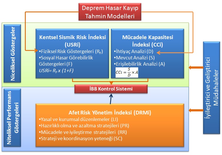
“Mega City Indicator System”; In disaster prevention and risk management studies, in addition to helping decision makers and managers develop correct strategies and make appropriate risk reduction decisions, it also enables all information and risk elements related to risks to be transferred to all stakeholders in the disaster prevention and risk management process. Thus, the verification (validation) of disaster prevention and risk reduction decisions and investments is also provided. The Mega City Indicator System consists of three components.
“Urban Seismic Risk Index”, where physical risks and social vulnerability are assessed,
“Combating Capacity Index”, where IMM’s post-earthquake emergency response capacity is assessed,
“Performance-Based Administrative Monitoring Process”, where IMM’s performance within the scope of relevant studies is analyzed by taking into account certain criteria.
This approach was initially developed by Omar CARDONA and his team at the National University of Colombia, Institute of Environmental Studies (IDEA) for the Inter-American Development Bank (IDB). Later, the Earthquake and Megacities Initiative (EMI) was inspired by this method and implemented as a “Megacity Indicator System” in Metro Manila, Barcelona, Colombia (Manizales), Ecuador (Quito) and Italy (Lombardy) with an application called “an innovative risk communication tool” (in collaboration with EMI and CIMNE).
“Megacity Indicator System” has been carried out by EMI, of which IMM is also a member, within the framework of “Cluster Cities” (Cluster Cities Information and Project Sharing)”; It has been carried out by the Earthquake and Ground Investigation Directorate since October 2007 under the consultancy of EMI, Kandilli Observatory and Karlsruhe University experts. The project summary regarding the indicators made with the existing data sets as of 2012 can be accessed from the link below.
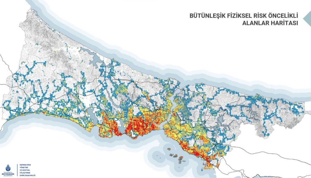
As of 2020, considering the re-examined data sets, the “Urban Seismic Risk Index” studies, which evaluate physical and social vulnerability, one of the 3 main components of the study, have been partially completed and have started to be used as the basis of urban transformation studies with earthquake priority. Earthquake damage estimation studies will be carried out for special layers within physical vulnerability (industry, cultural heritage, etc.), and earthquake loss estimates will be updated for the entire province in the light of current inventory data and scientific developments. In addition, the updating process of other components, the combat capacity and disaster management index studies, is ongoing.