Yükleniyor...
Istanbul Province Marmara Coast Tsunami Modeling, Vulnerability and Hazard Analysis Update Project Report, prepared by METU Civil Engineering Department, Marine Engineering Research Center and METU Geology Engineering Department, Remote Sensing and Geographic Information Systems Laboratory for Istanbul Metropolitan Municipality Earthquake and Ground Investigation Directorate.
The studies presented in the report include;
In this context, the first study conducted in Istanbul was the “Simulation and Vulnerability Analysis for Tsunami Waves That May Affect the Coasts of Istanbul” (İBB, OYO, 2007) carried out by the Istanbul Metropolitan Municipality Earthquake and Ground Investigation Directorate (İBB-DEZİM) in 2007. The results of this project were used as a base in the settlement suitability maps developed and have also been a guide for many infrastructure and superstructure investments. In the period up to the present day, there have been significant developments in both software and hardware technologies in numerical modeling tools, and in addition to these, very effective measurement and processing tools have begun to be used in data collection and processing methods. In line with all these scientific and technological developments both in our country and in the world, it was decided by İBB-DEZİM to re-analyze and evaluate the tsunami-related risks and risk components that may affect Istanbul, and thus the “Istanbul Marmara Coasts Tsunami Modeling, Vulnerability and Hazard Analysis Update Project” was implemented in cooperation with METU.
In this project, in order to obtain higher resolution and more detailed results, the most up-to-date and highest precision/accuracy digital elevation model, building data and road network data were processed in detail into the database and used as input in tsunami numerical modeling. This database was analyzed using the tsunami modeling software NAMI DANCE GPU version, all usage rights of which are held by METU. A tsunami numerical modeling database was prepared for the Marmara Sea at 42 m and for each district at 5 m, 7 m or 10 m levels, including buildings, roads and infrastructure facilities, and high-resolution simulations were performed with NAMI DANCE software using critical tsunami scenarios decided by numerical modeling performed separately for each district.
This level of resolution used within the scope of the project is a first among tsunami modeling, vulnerability and hazard analysis projects conducted for megacities in the world. With this project, possible tsunami scenarios based on existing data and high-resolution simulations were performed on a district and neighborhood basis based on the most detailed data; In tsunami-influenced areas, urban elements such as buildings, structures and roads, as well as natural (geology, slope, distance to the coast, landslides, etc.) conditions were taken into consideration and district and neighborhood vulnerability analyses were conducted with the MeTHuVA method.
NAMI DANCE software is a numerical model that solves tsunami formation and tsunami propagation at sea and on land using the numerical simulation method. This method is based on the solution of nonlinear long-wave equations according to initial and boundary conditions. The software was among the models that were determined to be accurate and valid in international benchmark problems scientific workshops where the accuracy and validity of tsunami numerical models were tested (Lynett, 2017). The GPU version of NAMI DANCE 2017 version, which has high resolution and very fast calculation capacity with the help of graphic processor units, was used within the scope of this project.
After the Tsunami Influence Maps were produced, these results were used as input in the MeTHuVA method. The MeTHuVA method (Figure 7) starts from two main factors in vulnerability analyses. These are the main factors Spatial Vulnerability (MHG) and Evacuation Resilience (TE). MeTHuVA vulnerability analyses are the effects of these two main parameters and their sub-parameters on Geographic Information Systems (GIS) based Multi-Criteria Decision Making Analysis (MCDA) methods were used to calculate all districts of Istanbul province that have coasts on the Sea of Marmara and most of the districts that have coasts on the Bosphorus.
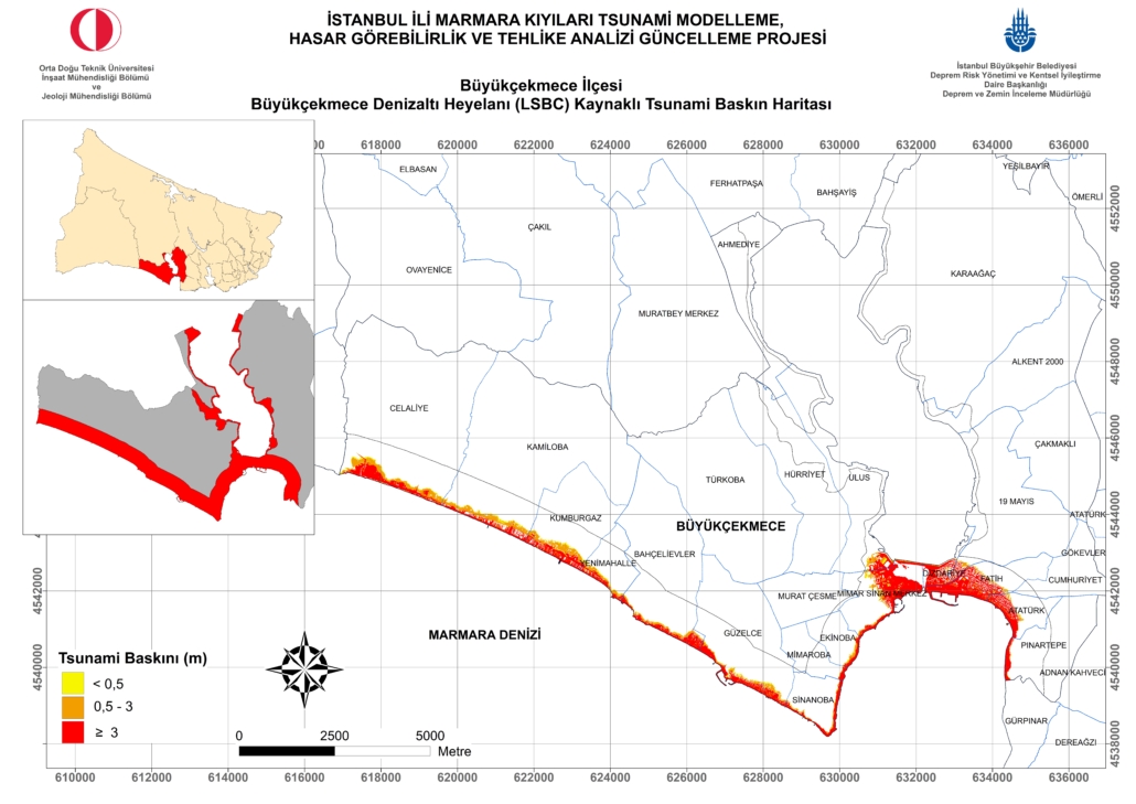
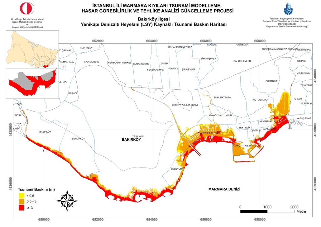
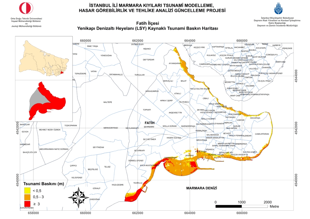
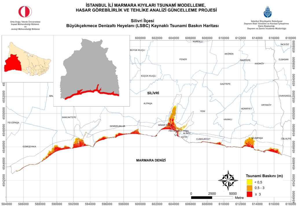
Tsunami-induced risk maps were obtained for each district as the final product, and comparisons and evaluations were presented using these maps. The existing data and the tsunami scenarios selected and used as inputs naturally contain uncertainties. Although these uncertainties have been taken into account, the location and characteristics of the tsunami that may occur with a possible earthquake in the Sea of Marmara may differ from those in this report. When the simulation results of submarine landslide-induced tsunamis for each district are examined, it is seen that there will be a tsunami effect of variable but significant sizes in all districts that have direct coasts on the Sea of Marmara, similar to the evaluation of seismic-induced tsunami effects. Due to the length of the coast and the relatively low elevation of these areas, Silivri district should be expected to be exposed to the most flooding. In possible tsunamis originating from the Büyükçekmece submarine landslide, the districts with high flood areas are, in addition to Silivri, Büyükçekmece, Bakırköy, Beylikdüzü and Avcılar districts. These districts are followed by Kadıköy, Maltepe, Fatih and Küçükçekmece districts. In possible tsunamis originating from the Yenikapı submarine landslide, the districts with high flood areas can be seen as Bakırköy, Tuzla, Maltepe, Kadıköy, Fatih, Kartal and Pendik districts, respectively.
Tsunami symptoms that have occurred at various times are summarized below;
As soon as possible, observe the behavior of the shore. If you see an unusual retreat or advance in the sea, the probability of a tsunami is very high. In this case, instead of following the behavior of the sea, go far away from the sea. Because most of the deaths occur during this time.
The time it takes for a tsunami to reach the shores for Istanbul is between 5-10 minutes. Depending on the center of the earthquake, this period may go up to 20 minutes.
In the event of a tsunami, the effective period in the Sea of Marmara is 90-120 minutes. Even if you see the sea calm down, be careful to stay away from the shore. Because the waves that will reflect from the opposite shores of Marmara may come to your location later.
If the height of the earthquake wave exceeds 2 meters, damages and significant property losses are expected in small boat shelters due to very strong currents. In places where the wave climb height exceeds 2.5 meters on the shores, property losses increase and in addition, there is loss of life.
Earthquake waves have occurred many times on the shores of Turkey throughout history. It should be expected to occur in the future.
An earthquake wave is not a single wave. It is usually in the form of a wave series consisting of four or five waves. The first wave is a gentleman's wave. The second and third waves are effective. The effect of the continuing waves is less.
The danger may continue for a few hours after the effective waves hit the shore. Wait until official statements are made and always stay away from the shore.
It is possible for people on land to get away from the shore 100-150 meters, and for people on boats at sea to get away from possible wave and current effects by moving away to places where the water depth is at least 50 meters or deeper.