Istanbul Province Marmara Coasts Tsunami Modeling, Vulnerability and Hazard Analysis Update Project Report has been prepared by METU Civil Engineering Department, Marine Engineering Research Center and METU Geological Engineering Department, Remote Sensing and Geographic Information Systems Laboratory for Istanbul Metropolitan Municipality Earthquake and Geotechnical Investigation Directorate.
The studies presented in the report
i) acquiring data and using these data to determine bathymetric and topographic data,
ii) Preparation of high-resolution data containing detailed buildings, infrastructure and coastal facilities for each district on the Marmara coast of Istanbul,
iii) Evaluation of tsunami sources that may occur in the Sea of Marmara, determination of seismic or non-seismic tsunami sources separately for each district,
iv) Calculation and evaluation of the movements of the tsunamis that will occur according to these sources in the sea, the changes until they reach the coasts, the elevations on the coasts and the inundation zones, on the basis of districts and neighborhoods,
v) taking into account metropolitan elements such as buildings, structures, roads and natural conditions (geology, slope, distance to the shore, landslide, etc.) in the inundation zones, and producing the high-resolution vulnerability distributions based on districts and neighborhoods, vi) calculation of the tsunami-related risk in each district using a new method named MeTHuVA.
In this direction, the first study in Istanbul was carried out in 2007 by the Istanbul Metropolitan Municipality Earthquake and Geotechnical Investigation Directorate (IMM-DEZİM); called “Simulation and Vulnerability Analysis Project for Tsunami Waves That May Affect the Istanbul Shores” (IMM, OYO, 2007). The results of this project have been used as a base in the settlement suitability maps and have been a guide in many infrastructure and superstructure investments. In the period until today, there have been significant developments in both software and hardware technologies in numerical modeling tools, and besides, very effective measurement and processing tools have started to be used in data collection and processing methods. In line with all these scientific and technological developments in our country and around the world, the IMM-DEZIM has decided to re-analyze and evaluate the tsunami risk and risk components that may affect Istanbul, thus implemented the “Istanbul Marmara Coasts Tsunami Modeling, Vulnerability and Hazard Analysis Update Project” in collaboration with METU. With this project, the most up-to-date and most accurate digital elevation model, building data, and road network data are detailed in the database and used as input in tsunami numeric modeling to achieve higher resolution and more detailed results. This database has been integrated into the analysis using the version of the Nami Dance GPU of the tsunami modeling software available at METU. 42m resolution for the Marmara Sea bathymetry and 5m, 7m or 10m resolution for each district’s, buildings, roads and infrastructure facilities are incorporated into the tsunami numeric modeling database and high-resolution simulations with NAMI DANCE software have been performed for each district using numerical modeling for critical tsunami scenarios.
This level of resolution used in the scope of the project is a first among the tsunami modeling, vulnerability and hazard analysis projects for mega-cities around the world. With this project, possible tsunami scenarios based on the data available and based on the most detailed data were used with high-resolution simulations for districts and neighborhoods. District and neighborhood-level vulnerability analysis were conducted using MeTHuVA method by taking into consideration natural (geology, slope, distance to shore, landslide, etc.) and urban elements such as buildings, structures and roads in tsunami inundation zones.
THE NAMI DANCE software is a digital model that solves the formation of tsunami and the spread of tsunami in the sea and on land using a digital simulation method. This method is based on the solution of nonlinear long wave equations based on the initial and boundary conditions. The software was among the models that were found to be true and valid in scientific workshops, where the accuracy and validity of the tsunami digital models were tested (Lynet, 2017). The GPU version of NAMI DANCE 2017, with the help of Graphics processor units, is capable of high resolution and very fast calculation, is used within this project.
After producing the tsunami inundation maps, these results were used as input in the MeTHuVA method. The MeTHuVA method (Figure 7) is driven by two main factors for vulnerability analysis. These are Spatial Vulnerability (MHG) and Evacuation Flexibility (TE). MeTHuVA vulnerability analysis is carried out using these two parameters and their sub-parameters, using the Geographic Information Systems (GIS) based Multi-parameter decision analysis for all the districts of the city of Istanbul with the coastline of the Marmara Sea and the districts of the Bosphorus of Istanbul, as part of the project.
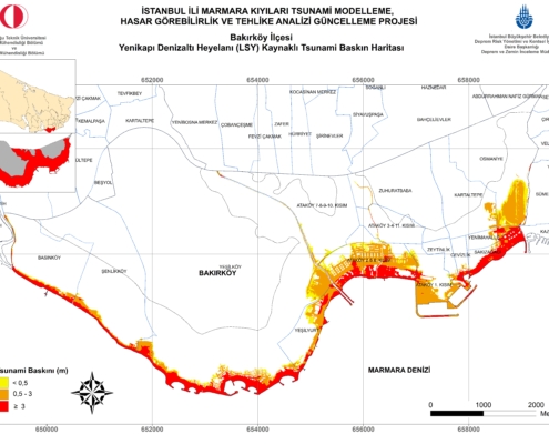
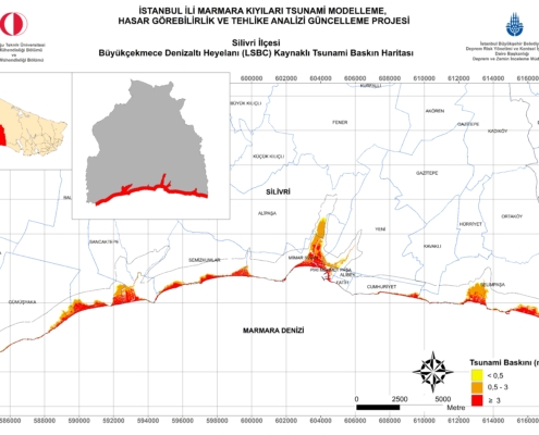
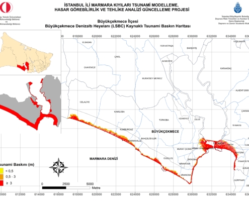
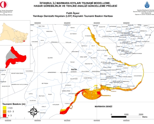
As the final product, tsunami-induced risk maps have been obtained for each district, comparisons and evaluations are presented using these maps. The current data and the tsunami scenarios selected and used as inputs, naturally contain uncertainties. Although these uncertainties have been taken into account, the location and characteristics of the tsunami that may occur in the Marmara Sea with a possible earthquake may differ from those contained in this report. When the simulation results of tsunamis induced by submarine landslides are examined for each district, similar to the evaluation of seismic-induced tsunami effects, there will be a variable but significant tsunami effect in all districts which have a direct costal connection to the Marmara Sea. Due to the shore length and the relatively low-elevation, Silivri district should be expected to be exposed to the maximum flooding. In addition to Silivri, the districts with high inundation area are Büyükçekmece, Bakırköy, Beylikdüzü and Avcılar, following a tsunami caused by Büyükçekmece submarine landslide. The districts of Kadikoy, Maltepe, Fatih and Kucukcekmece follow these districts. With the possible tsunamis from the Yenikapı submarine landslide, the districts with high inundation area are expected to be Tuzla, Maltepe, Kadıköy, Fatih, Kartal and Pendik districts.
Examples of Upcoming Tsunami Signs
The tsunami signs from various times are summarized below;
– Earthquake can be felt
– Large quantities of gas bubbles can be seen water surface, and can also display in the form of boiling.
– Seawater may be warm above the usual.
– Seawater can smell like rotten egg (Hydrogen sulfur) or oil spill.
– Sea water can disturb the skin.
– Sounds like thunder, such as jet plane sound, helicopter, whistling sound can be heard.
– The sea can retreat a significant amount from the shore.
– A red flash light can be seen on the horizon line.
– When the wave is approaching, a redness can be seen at the top of the wave.
If you are on the coast and you feel a low-intensity earthquake:
– Look at the behavior of the seashore at the earliest opportunity. If you see any unusual retreat or progress in the sea, there is a very good chance that tsunami will come. In this case, instead of watching the sea behave, you go away from the sea. Because that’s when most of the casualties are happening.
– The time for tsunami to come to the shores for Istanbul is 5-10 minutes. Depending on the center of the earthquake, this time can also be up to 20 minutes.
– In the event of tsunami, it might continue up to 90-120 minutes in the sea of Marmara. Be careful to stay away from the shore even if you see the sea settle. Because the waves that will be reflected from the opposite shores of Marmara can come later to your location.
– If the tsunami waves exceed 2 meters, damage and significant loss of property is expected due to severe currents in small boat shelters. In places where the wave has more than 2.5 meters run-up height, property losses are increased and in addition, life losses are occurring.
– There have been several tsunami waves on the Turkish coast in history. It should then be expected to occur.
– The tsunami wave is not a single wave. It is typically a waveform of four or five waves. The first wave is less harmful. The second and third waves are effective and prone to cause more damage. The effect of the waves in progress is less.
– The danger may continue for a few hours after the effective waves hit the shore. Wait until the official explanations are made and stay away from the shore at all times.
– People on land should move away from the shore 100-150 m away, and those who are on the boat at sea, should go away from water depths of at least 50 m or deeper, to avoid potential waves and currents.

